

Harder Kulm Hike: A Trek to Alpine Splendor
Harder Kulm Hike | At a Glance

- Length of Hike: 4.5 kilometres (one way), 9 kilometres (roundtrip)
- Ascent: 670 meters
- Estimated Duration: 2.5 to 3 hours (one way), 3.5 hours (roundtrip)
- Difficulty Level: Moderately challenging short hiking trail, but quite steep
- Crowd Footfall: High
- Cost: Funicular (included with Swiss Pass) is INR 800 (one way), and Funicular (without Swiss Pass inclusion) is INR 1,600
- When to Visit: Best weather conditions are witnessed between June and September
Also Checkout: Things to Do in Harder Kulm
What To Expect On Harder Kulm Hike

- At the beginning of the hike, about 100 meters ahead, you'll reach the first stop which is called Alpine Wildlife Park
- Get a chance to spot animals such as the rare Ibex and a colony of playful marmots.
- The incline becomes steady right after you move ahead of the Wildlife Park, and continues till the top.
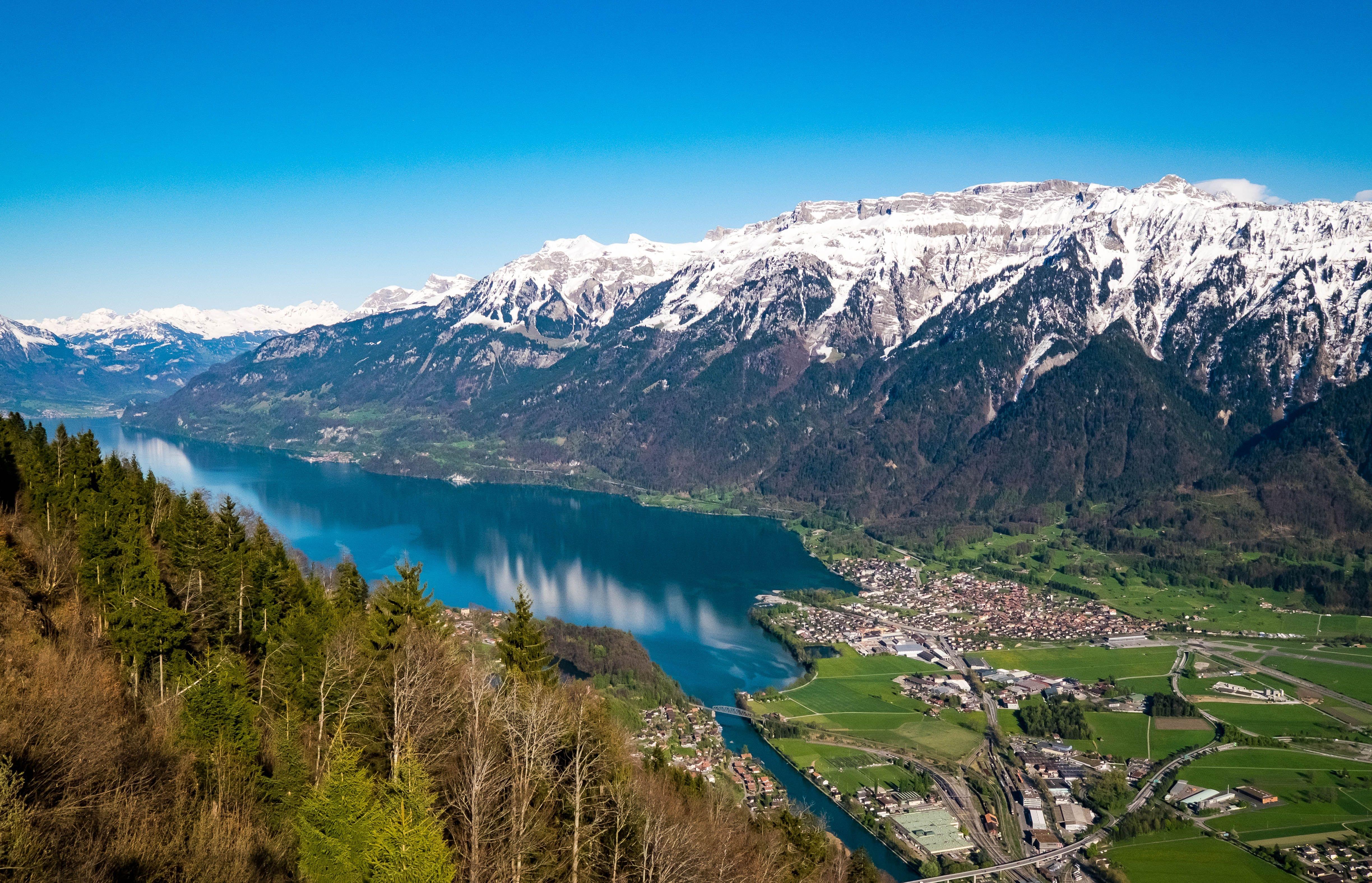
- As you hike your way up, you can catch a glimpse of the valley below you.
- Proceeding towards the top, through the trails wrapped along the side of the mountain, you'll reach the Hardermandii viewpoint.
- Catch your breath at the viewpoint and admire the beautiful views of the surrounding mountains.
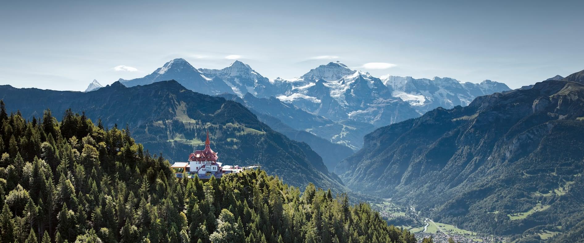
- After the break, you'll continue on the trail via the switchbacks that lead to Harder Kulm Panorama Restaurant.
- Upon reaching, you can either grab a snack at the restaurant or enjoy the stunning views from the top.
Hiking Routes For Harder Kulm
.jpg?w=340&dpr=2)
Main Interlaken Route:
- The most commonly used trail starts close to Interlaken Ost station, near the Harderbahn valley station.
- The path climbs through shaded forest, offering a steady gradient for most of the way.
- Occasional clearings provide views over Interlaken, Lake Thun, and Lake Brienz.
- The climb is continuous and requires stamina, with an average hiking time of two to three hours.
Direct Steeper Ascent:
- A steeper variant begins from the Harderbahn valley station.
- This path is shorter but has steeper inclines, making it physically more taxing.
- Hikers seeking a quicker and more challenging climb often use it.
- Although demanding, it allows an earlier arrival at the summit platform.
Village Approaches (Unterseen, Goldswil, etc.)
- Additional trails connect from nearby villages and link with the main route.
- These routes pass through meadows, wooden bridges, and quieter wooded areas.
- They take longer than the direct ascent but offer a more peaceful environment away from the busiest portions.
- They are best suited for hikers who want to admire various views and go at a leisurely pace.
Know Before You Go For Harder Kulm Hike

- Location: Haredr Kulm, Interlaken Höheweg, 35 3800, Interlaken
- Best Time: Harder Kulm hiking expeditions are available throughout the year. Most of the tourists prefer to head out for hikes between July and August, which offers comfortable weather. However, the best time for hiking to Harder Kulm depends on your personal and seasonal preferences.
Also Checkout: How to Get to Harder Kulm

- Remember to wear sturdy and comfortable hiking shoes to ensure a good grip while hiking on the challenging trails.
- Pack 3-4 water bottles with you to stay hydrated throughout the hiking expedition.
- Consider keeping some packets of ready-to-eat snacks to re-energize on the go.
- The Harder Kulm Hike is at an elevation of 773 Meters and it is highly advisable to wear sunglasses to avoid the sun's glare.
- Always check the weather for the day you are planning the hike.
- Wear clothes that suit the weather during your visit.

The Harder Kulm hike is an 8.2 km trail that begins from Bern, located near Interlake. It's considered to be a moderately challenging route and takes roughly 3.5 hours to complete. Travelers from all over the world opt for the Harder Kulm trail to experience the panoramic views of the valley. The trail is short but features an ascent of 670 meters and includes multiple switchbacks.

FAQ's
How long does it take to hike up Harder Kulm?
It takes around 3.5 hours to complete the Interlaken to Harder Kulm hike. During this timeframe, you need to cover a distance of around 8.5 km. Many tourists from all over the globe visit Interlaken to opt for the hike, which offers incredible views of the landscape from the top.
Where to start hiking the Harder Kulm?
You can begin the Interlaken Harder Kulm hike from the funicular station itself. You'll need to cover around 8.5 km and it will take you approximately 3.5 hours to reach the summit. Upon reaching, you can visit the Two Lakes Bridge which offers fantastic views of the Jungfrau, Mönch, and Eiger peaks.
How hard is a Harder Kulm Hike?
A hike to Harder Kulm is moderately challenging and features short but steep trails. Despite being challenging, the hiking trail is a popular choice among travellers from different parts of the world. You will get a chance to witness the breathtaking sight of the Interlaken's natural landscapes. If you're looking for a comfortable option, you can always opt for the 10-minute funicular ride to the summit.
How high is the Harder Kulm?
Harder Kulm, also known as 'the top of Interlaken', stands at a height of more than 4,300 feet. It is located in Switzerland's Bernese Highlands region and is known for its magical landscapes. Harder Kulm is popular among tourists for offering stunning views of the majestic peaks of Eiger, Mönch, and Jungfrau from the Summit.
How much is the harder kulm hike difficulty?
Harder Kulm hike difficulty is considered to be that of a moderate level. Most of the hikers with a basic fitness level can easily hike to the Summit level. It usually takes around 3.5 hours to reach the mountain top (breaks included). However, if you prefer a more convenient option, you can take the 10-minute funicular ride to the Summit.
What is the duration of the Harder Kulm Hike?
The Harder Kulm hike generally takes around 3.5 hours to complete. It begins at the base of the mountain, near the funicular station. You will need to cover a distance of 8.5 km from the base, to reach Harder Kulm Summit. Upon reaching, you can head to the viewing platform or enjoy walking on the Two Lakes Bridge.
What is the best time to hike at Harder Kulm?
Harder Kulm welcomes tourists from across the globe, throughout the year. However, the best time to visit depends on your personal and seasonal preferences. Most of the visitors choose to visit Harder Kulm between June and August because of the pleasant weather. If you want to avoid crowds, it's recommended that you explore Harder Kulm in May or September.
How long is the Harder Kulm hiking?
Harder Kulm hiking expeditions cover a distance of 8.5 km from the base to the summit. The trails are known to be short and steep, and feature an elevation range between 660 and 700 m. Many tourists visit the mountain to enjoy the stunning views of Lake Brienz and Lake Thun from the top. You can also take a look at many mountain peaks like Mönch, Jungfrau, and Eiger.
Is the Harder Kulm hike worth it?
Yes, the Harder Kulm Interlaken hike is one of the most loved hikes in the region. You will get a chance to hike through scenic trails which are covered in tall trees. Upon reaching the summit, you can also choose to visit the viewpoint and admire the breathtaking views. Moreover, remember to visit Harder Kulm Panorama Restaurant, and enjoy a delicious meal.
Is Harder Kulm trek easy?
The Harder Kulm trek is a very steep climb and due to its elevation of 773 meters and the climate of the area it is classed as moderately tough to hard. It also depends on your health as at that altitude there might be some trouble breathing.
How to get to the Harder Kulm hike trailhead?
If you are arriving at the Harder Kulm Hike by car you can park at the inexpensive Parkplatz. It is the main parking lot for the train station and is a mere 7 minute walk from the plot to the start of the Hike. If you are arriving by public transport you should know that there aren't any buses that take you to the beginning of the Harder Kulm trek but you can take a bus to the Interlaken OST or the Bahnhof that is the Interlaken train station from which it will take you approximately 5 minutes to reach the trailhead.
Where to stay for Hiking in Harder Kulm ?
There are two options where you can stay if you go hiking at Harder Kulm, one of them is the Wilderswil, it is a small town with shops, restaurants and a train station. Apart from Wilderswil, there is also the Interlaken which is perfect if you are traveling by public transportation as it has bus stops and train stations and if you intend to visit the Two Lakes you should definitely stay at the Interlaken.